
Historical Shoreline
Ancient Shoreline
The temporal sequence for the archaeology of the San Francisco Bay Area is organized into broad geologic time segments defined by calibrated years before the present (cal BP):
- Terminal Pleistocene: 13,500 – 11,700 cal BP
- Early Holocene: 11,700 – 8200 cal BP
- Middle Holocene: 8200 – 4200 cal BP
- Late Holocene: 4200 – 180 cal BP
- Mission/Historic: 180 – 115 cal BP
The data from this report focuses on the Middle Holocene period.
From an Inland River Valley to the San Francisco Bay
Between 10,000 and 13,000 years ago, the San Francisco Bay was an inland river valley located 15 to 30 miles from the Pacific coast.
- Valley Inundation (12,000–9,000 BP): Melting ice sheets raised sea levels by 230 feet, driving ocean waters through the Golden Gate and flooding the inland valley.
- Tidal Marsh Formation (7,000–6,000 BP): As sea level rise slowed, sediment accumulation created widespread tidal marshes, mudflats, and estuarine habitats.
- Early Shoreline Settlement (6,000 BP–Present): Stable marshlands enabled sustained shellfish harvesting, resulting in shell middens along the bayshore—many of which now sit submerged under Bay mud.

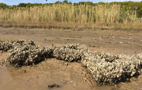
The abundance of native Olympia oysters (Ostrea lurida) in the site deposit marks a critical ecological turning point beginning around 8,000 years ago:
- Salinity Thresholds: Olympia oysters require stable salinity levels above 25 parts per thousand to form sustainable intertidal reefs.
- Estuarine Stability: Prior to 8,000 BP, rapid sea-level rise and variable freshwater flows prevented oyster reef establishment.
- Earliest Shellfish Economy: The CCA site captures the earliest known period when Bay conditions could support sustained shellfish harvesting—the foundational adaptation that later gave rise to the region's massive shellmound landscape.
Given the even more rapid rate of sea level rise during the Early Holocene, the very small size of the bay prior to 8,000 BP, and the tidal waterflow dynamics, which would have resulted in high variability in salinity and effects from freshwater inputs; the beginning of the Middle Holocene (when the CCA project site was occupied) may represent the earliest period in the bay that a shellfish subsistence economy could have been viable; the same adaptation (though on a much smaller scale) that eventually gave rise to the massive San Francisco Bay shellmound landscape later in the Middle and Late Holocene.
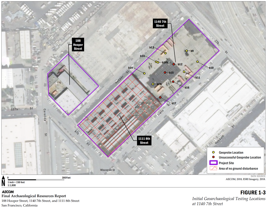
Archaeological Testings at the CCA Project Site
In 2018, AECOM conducted geoarchaeological testing across a grid of 12 deep Geoprobe cores at 1140 7th Street (now "Double Ground"). Over 41 feet below the asphalt, city fill, and dense layers of Young Bay Mud, core Bore 14 struck a thin, intact shell midden—uncovering an ancient living surface that had remained sealed and preserved for nearly 8,000 years.
- Oldest Shoreline Site (7,800–7,400 BP): Radiocarbon dating of oyster shell, charcoal, and sediment dated the midden to ~7,800 years before present—making it the oldest documented shell midden on the San Francisco Bay shoreline.
- Invertebrate Assemblage: Heavily dominated by native Olympia oyster (Ostrea lurida) and bay mussel (Mytilus trossulus), confirming stable estuarine conditions by the Middle Holocene.
- Fish & Vertebrate Fauna: Identified 15 fish taxa (primarily small schooling species like silversides and herring harvested via net, basket, or weir), alongside sea otter, harbor seal, Tule elk, and rare jaw fragments of Chendytes lawi—an extinct flightless sea duck previously undocumented in Bay Area archaeology.
- Seasonal Plant Processing: The site contained the only known Middle-Holocene floral assemblage on the Bay shoreline. Abundant Brodiaea corms and small seeds indicate a spring-and-summer occupation pattern.
Contemporary Shoreline Transformation
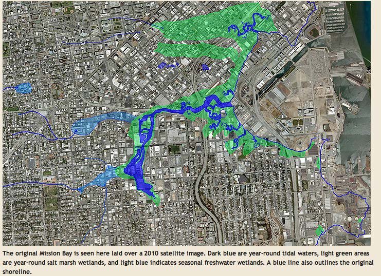
In the second half of the 19th century, a confluence of resource extraction, transit infrastructure, and municipal development radically transformed Mission Bay, replacing a shallow tidal estuary with heavily filled urban land.
- Estuarine Context & Hydraulic Mining: Sierra Nevada gold mining washed millions of tons of sediment down river systems into the Bay, causing widespread shoaling. Before intervention, Mission Bay was a shallow, half-moon estuary measuring three-quarters of a mile across, fed by Mission Creek near modern-day Division and De Haro streets.
- The Long Bridge & Rail Expansion (1868): Development accelerated with the construction of the wooden Long Bridge across Mission Bay along modern Third Street, linking downtown San Francisco to Potrero Point. That same year, the Southern Pacific Railroad acquired 60 acres of tidelands, sparking systematic landfilling to establish shipping terminals and railyards.
- The Municipal Dump (1869–1890s): The City established an official dump on Berry Street between 5th and 6th streets. As many as 300 horse-drawn carts a day deposited city refuse directly into the marshlands, pushing artificial land south and east toward Channel Street and encroaching on the CCA site.
- Industrialization (1899–1913): The 1899 Sanborn Fire Insurance Map records 188 Hooper as "Tide Water Mud Flats at Low Tide," while 1140 7th Street was filled but undeveloped. By 1913, the entire project block was fully filled and covered in light-industrial facilities—including paint, oil, and glass works—establishing an industrial footprint that defined the site until CCA’s campus expansion.
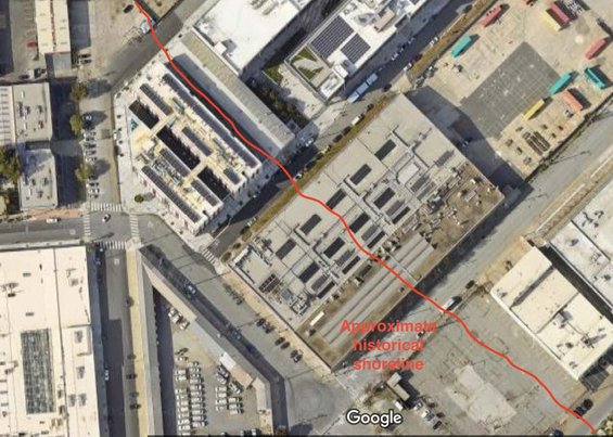
The picture on the left shows the approximate historical shoreline. The new sidewalk on Hooper is constructed in black asphalt with a brightly painted line painted on, showing the original shoreline.